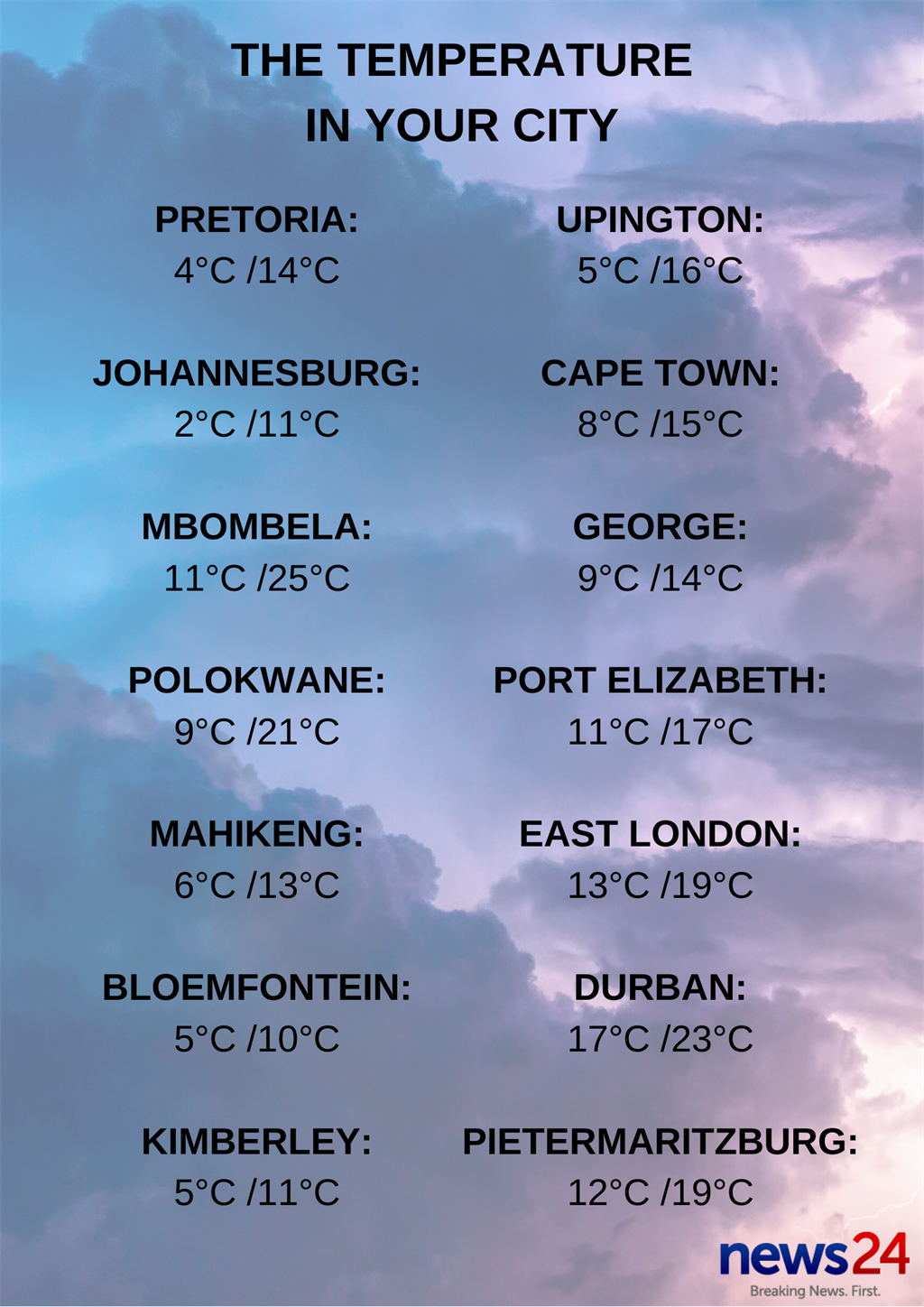
The South African Weather Service forecasts another day of heavy rain, biting cold and some light snowfall. In other words: The perfect stay-in weather for Saturday.
Warnings:
– Extremely high fire danger conditions are expected over the eastern parts of both Limpopo and Mpumalanga as well as the north-western parts of KwaZulu-Natal.
– Gale force west-south-westerly winds (65-80km/h) are expected along the coast between George and East London, moderating from the west.
Special weather advisories:
– Very cold and windy conditions expected in places over the southern parts of the Northern Cape, southern parts of Free State, northern interior of the Eastern Cape and the high ground of the Western Cape.
– Snowfalls are expected over the high-lying ground of the southern parts of the Northern Cape, spreading to the southern parts of the Free State as well as the high ground of the Eastern Cape.
– An intense cold front is expected to affect the Western Cape and Northern Cape late Sunday overnight into Monday. The public and small stock farmers are advised that gale force winds, heavy rain, flooding and very cold conditions, as well as rough seas, are expected.
The weather in your region:
Gauteng will be fine, windy and cold.
The expected UVB sunburn index is moderate.
In Mpumalanga, it will be fine, windy and cold, but warm to hot in the lowveld. It will become partly cloudy in places on the highveld from mid-morning.
Limpopo will be fine, windy and cool, but warm to hot in the Limpopo Valley and lowveld.
The North West will be cloudy in the west, otherwise partly cloudy, windy and cold, but clearing from the afternoon.
The Free State will be cloudy at times, windy and cold, but very cold in the south, where isolated showers and rain are expected. There will also be light snow and graupel, especially over the high-lying areas.
The Northern Cape will be cloudy and cold to very cold, with isolated rain and showers. Snowfall can be expected over the southern high ground.
It will become partly cloudy from the late afternoon. The wind along the coast will be moderate south-westerly, becoming south-easterly by afternoon.
The Western Cape will be cloudy and cool to cold, with scattered showers and rain along the west, south-west and south-coast areas, but isolated over the interior.
Snowfalls can be expected over the mountainous areas.
It will become partly cloudy by late afternoon.
The wind along the coast will be fresh to strong south-westerly, becoming moderate to strong westerly.
The expected UVB sunburn index is low.
The western half of the Eastern Cape will be cloudy and cold, but very cold in the north, with scattered rain and showers along the coast and adjacent interior, becoming partly cloudy from the west in the evening.
Light rain is expected in places over the interior, with snowfalls over the high-lying areas in the morning.
The wind along the coast will be fresh to strong westerly, becoming moderate to fresh south-westerly in the afternoon.
The eastern half of the Eastern Cape will be cloudy and cold, but very cold in the north, with isolated rain and showers in the south-west during the evening.
Light rain is expected in places over the interior, with snowfalls over the high-lying areas. The wind along the coast will be fresh to strong south-westerly, reaching gale along the Wild Coast during the afternoon.
It will be fine and cool but warm in KwaZulu-Natal.
It will become partly cloudy in the east in the afternoon, with the possibility of isolated showers.
The wind along the coast will be moderate to fresh north-easterly, becoming south-westerly in the afternoon.
The expected UVB sunburn index is low.


The forecast 11 July.
– Compiled by Kerushun Pillay

